Archaeology & Forensics

Archaeology & Forensics

Archaeologists and remote sensing specialists around the world rely on GSSI ground penetrating radar (GPR) as a key tool for non-invasive site investigation. Whether the goal is site mapping for excavation or locating sensitive cultural resources for preservation or avoidance, GSSI's remote sensing technologies have been the tools of choice for over 50 years.

GPR is used by law enforcement and crime scene investigators to locate clandestine burials and buried objects. GPR has been instrumental in locating victims, hidden caches of weapons or evidence, and helping to locate the remains of soldiers and civilians killed in war zones.
Archaeology
  • Excavation Planning
  • Cemetery Mapping
  • Cultural Resource Management
Forensics
  • Evidence Locating
  • Clandestine Grave Locations
Archaeology

Archaeology: Excavation Planning

Archaeological and forensic investigations are often expensive and time-consuming, and there is always a risk of missing significant targets. A ground-penetrating radar survey can efficiently map landscape-scale subsurface targets, facilitating a more refined and informed investigation. GPR data can reveal vertical and horizontal relationships between important archaeological and landscape features, such as buried structures, wells and privies, and historical roads. These data can then be used to guide excavation efforts and minimize impacts to the landscape.

GPR data from a buried historical structure, showing time slice data at multiple depths. With data like these, excavation planning can incorporate horizontal and vertical anomaly patterning, and assess important areas for archaeological ground-truthing or resource avoidance. For analysis purposes, time slice data can reveal contextual information regarding site layout and the spatial relationship between features.

Archaeology: Cemetery Mapping

Many historical and more recent cemeteries contain unmarked graves. This is usually a byproduct of fallen and/or relocated grave markers, though in some cases there may never have been a stone or other marker. Unmarked graves are also common to historical landscapes, battlefields, and crime scenes. Ground -penetrating radar is a high-resolution and non-invasive method for finding these burial sites. Cemetery surveyors typically look for grave shafts that are vertical stratigraphic cuts, hyperbolic targets suggestive of coffins or vaults, and geometrical patterning in 3D time slices.

These data examples exhibit the results of gridded GPR surveys in cemeteries. On the left is a GPR time slice from a 19th to 20th century pauper cemetery in New Hampshire. The image to the right shows unmarked graves with time slices overlaid on a drone-derived aerial photograph and a digital elevation model.

GSSI Solution - Archaeology - Data Example 3

Archaeology: Cultural Resource Management

Archaeologists use GSSI ground penetrating radar during phase II site investigation in order to maximize phase III data recovery.

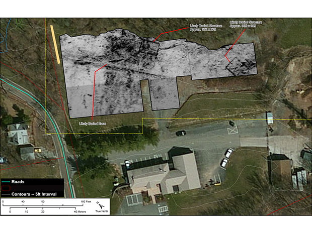
Identification of buried historical structures in conjunction with CRM projects. This image shows 18th Century mill foundations and a mill race that supplied water power for machinery. The SIR 3000 and 400 MHz were used in this survey.

Forensics

GSSI Solution - Forensics - Data Example 1

Forensics: Evidence Locating

Ground penetrating radar can assist law enforcement and crime scene investigators in locating evidence behind brick or concrete walls, wooden floors or in hidden compartments. GPR can also aid in ruling out suspect areas in minutes.

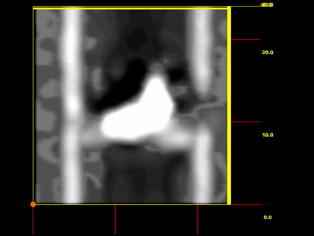
This data example was in a simulated wall with 2×4 construction with a 9mm handgun sitting on a horizontal 2×4. Data was collected with a SIR 4000 and a 2 GHz Palm Antenna, and post-processed using the 3D Module in RADAN 7.

GSSI Solution - Forensics - Data Example 2

Locate Clandestine Graves

Ground penetrating radar is an invaluable aid to law enforcement in locating disturbed sites and shallow graves that are nearly undetectable when viewed from the surface.

Identification of excavated and filled trenches in a field. This GPR time slice data shows a rectangular backhoe trench and tire tracks. This data was collected with the SIR 4000 and a 300/800 dual-frequency digital antenna.

Data Processing

Exponential Range Gain

RADAN® 7 is GSSI’s state-of-the-art post-GPR processing software. A powerful and versatile software platform, RADAN excels at processing 2D GPR profiles and creating 3D time slice datasets. Post-processing GPR data is a critical component of surveys, since archaeological and forensic targets are often subtle and variably preserved. RADAN provides intuitive processing methods for optimizing GPR data and removing noise and other unwanted data components.

In this example, raw GPR data (top) required time variable gain enhancement. An Exponential Range Gain was applied to optimize signal amplitudes across the profile’s depth range.

Advanced Migration

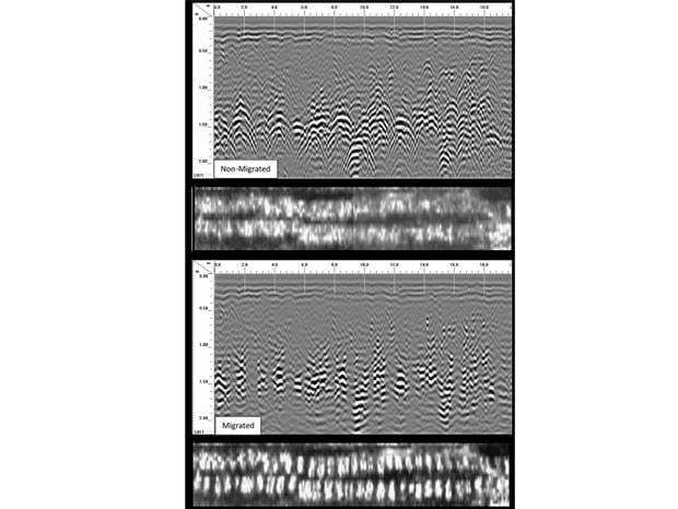
Use RADAN 7’s advanced Migration process to calibrate the vertical depth scale and enhance mission planning for excavation efforts. Migration also improves the visualization of 3D time slices by refining the geometry of targets.

In this example, unmarked historical graves were visible in the GPR profiles, but in the non-Migrated time slices their geometry was obscured by overlapping hyperbolic tails (top). A simple Migration was applied, and the time slices were much easier to interpret (bottom).

IIR Filter

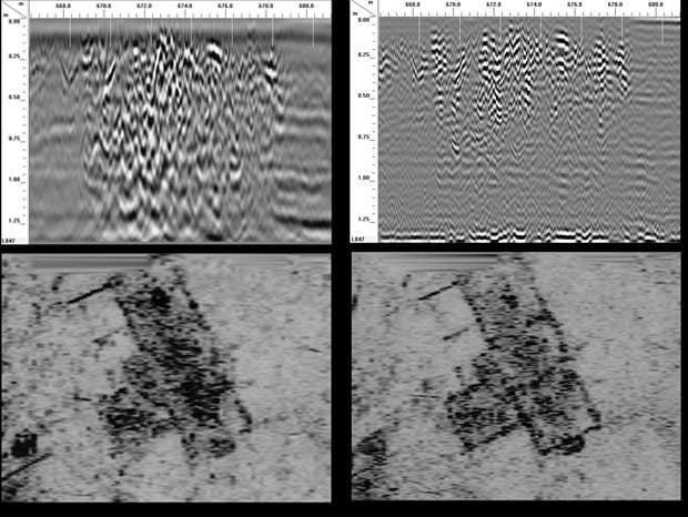
RADAN 7’s powerful IIR Filter can remove external noise interference from GPR data. This is especially useful for surveys in urban environments, or project areas near radio or cellular towers. IIR can also manipulate your data’s frequency spectrum, providing a customizable band pass.

In this example from a buried historical foundation, a 400MHz dataset was IIR filtered to remove all frequencies below 700MHz and all frequencies above 800MHz. The resulting dataset (top/bottom right) exhibited cleaner and more refined time slices, which highlighted internal structural features that were not visible in the full spectrum dataset (top/bottom left).

Super 3D

Large project areas often require collection of several grids and dealing with numerous obstacles (trees…). RADAN 7’s 3D Module simplifies this process with the creation of Super3D files. Multiple grids are quickly combined into a single grid file based on their local XY coordinates. These grids are then viewed and processed simultaneously, greatly increasing processing efficiency and enhancing the correlation of targets in adjacent grids. Furthermore, line segments can be added to avoid obstacles, and GPS coordinates can be added to grid corners for georeferencing.